


Heat Wave Data Analysis
by Dylan Mathieu of West High School, Madison, Wisconsin
Summer 2003
Introduction
Although there is no exact scientific definition of a heat wave, meteorologists tend to agree that a heat wave constitutes several consecutive days of extremely high temperatures. Often, this heat is accompanied by high levels of humidity, which further the negative effects of the high temperatures upon the body, making the temperature intolerable. Heat waves are very dangerous to humans. Along with frigid cold of winter, heat is considered to be the deadliest natural hazard in America. While a heat wave poses few visible threats, unlike a tornado or thunderstorm, it causes damage by taxing a human beyond his or her limits. Under normal conditions, the body produces perspiration, which evaporates, thereby cooling the body. However, during times of severe heat and/or humidity, the body's natural cooling cycling is slowed considerably, so the body has to work exceedingly hard to maintain nominal temperatures.
There are several negative effects of a heat wave and certain categories of people are more susceptible to these dangers than others. The first condition people often suffer from is heat cramps. While not dangerous, these are the first sign that the heat is affecting the body. After cramps, heat exhaustion typically results and is characterized by mild shock, as the internal organs receive less and less blood. Eventually, this morphs into heat stroke, which is also known as sunstroke. Heat stroke is potentially life threatening, because the body's temperature control system shuts down. If the person's body temperature is not cooled quickly, brain damage and death can result. The first to suffer from the effects of a heat wave are the elderly, young children, and those who are overweight or sick. Also, men are more likely to suffer from dehydration than women because they sweat more. Along with the direct injuries associated with heat waves, countless pre-existing medical conditions are exacerbated by the stress placed on the body by the extreme temperatures.
Heat waves kill over 300 Americans every year, and are responsible for countless other deaths indirectly. According to one nationwide study, 20,000 people died between 1936 and 1975 as a direct result of extreme temperatures and humidity levels (See Heat Wave a National Problem.) Along with the rest of the nation, Wisconsin is affected by heat waves as well, although not to the extent of other regions such as the southwest. Two recent heat waves, occurring in 1995 and 1999, recorded extremely high temperatures and caused many deaths and injuries. In 1999, there were an estimated 232 deaths, with temperatures reaching 90 degrees over a 24-hour average (Meteorology: Understanding the Atmosphere, pg. 258). However, this pales in comparison to the "super heat wave" during the summer of 1995, which claimed the most lives of any weather event over the last 50 years in Wisconsin. To put that figure in perspective, the record heat wave in Europe in August 2003 killed an estimated 15,000 people in France alone, making it the most deadly heat wave in recent history.
Data Information and Sources
Heat waves combine several factors along with high temperatures, including humidity, and are usually accompanied by a drought, which furthers heat stress. However, for this study, the data used includes only the maximum temperature for each day. Maximum temperature is defined as the single hottest temperature reached at any point during the 24-hour period (not as the average maximum temperature for the day). The data used originated from the National Climatic Data Center (NCDC), as was collected by the Dane County Regional Airport weather station. It encompasses every day of July from, and including, 1948 to 2002, a period of 55 years.
The following instructions are for accessing and utilizing the data available at the NCDC website.
- Use the web address: http://lwf.ncdc.noaa.gov/oa/ncdc.html
- Go to "Weather Station/City" under "Locate NCDC Products."
- Then click on the "State." Option and type in "WI" in the search box. This will give you all the data for any station in Wisconsin We used the records for the Madison Dane Co. Regional airport station.
- Once you've clicked on a station, click on "DATA" on the right hand side.
- Click on "Digital ASCII Files."
- Then you can click on "SOD - Daily Surface Data..."
- Choose Continue with Advanced Options.
- From there you can choose which weather elements you want, and for what time range.
- Select "Delimited - No Station Names." and "Space, without data flags." (right side)
- Click on Continue When it asks you for an email address, be sure to use one that ends in "edu." That way it's free.
- Click Submit Request Bookmark the next page titled SOD - Surface Data, Daily - US & some non-US, Data Access, so that it can be usable in the future
- When you have received E-mail notification, or have waited several minutes, click on the first of the contents, labeled Data file
The upcoming data analysis includes the following statistical terms:
Box Plot – A graph that depicts the variation and central tendency of data.
Daily Mean – the average temperature for a day.
Interquartile Range – the difference between the 1 st and 3 rd quartiles, or 25 th and 75 th percentiles.
Maximum – the highest value (e.g. warmest temperature) that was recorded for a given day.
Median – the value in a data set that has an equal number of values falling above and below it. For an odd number of values, arranged from lowest to highest, the median is simply the middle value. For an even number of values, the median is the average of the two values at the center. (Also called the 50 th percentile, or 2 nd quartile).
Minimum – the lowest value (e.g. coldest temperature) recorded for a given day.
Normal – the mean value of a weather element, such as temperature or precipitation, averaged over a period of 30 years.
Quartile – the 25 th, 50 th and 75 th percentiles make up the 1 st, 2 nd, and 3 rd quartiles, in that order.
Range – the difference between the maximum and minimum values.
Data Analysis
The first calculation was an average for the daily temperatures for each month. This showed that July is the hottest month in Madison the vast majority of the time, with only four exceptions (1995,1996,1999,2000), all of which were August instead.
The hottest week of August was then calculated, based on the weekly temperature averages from all 55 years. Based on the following graph, it is clear that the 3 rd week of July has the highest temperatures, although by less than half of a degree.
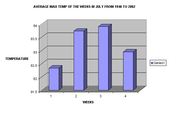
Figure 1 - Average of maximum temperatures for the four weeks of July from 1948 to 2002
To further understand the variations of temperature in July, the daily averages were calculated. The subsequent graph (next page) portrayed several peaks, most notably the 16 th through the 18 th and the 24 through the 27 th. There is also a general trend of increasing temperatures until the 18 th, and then decreasing temperatures thereafter. This graph also helps to reinforce the 3 rd week having the highest temperatures, because the fluctuation is visible.
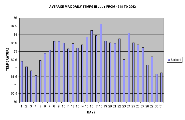
Figure 2 – Average Maximum Daily Temperatures in July From 1948 to 2002
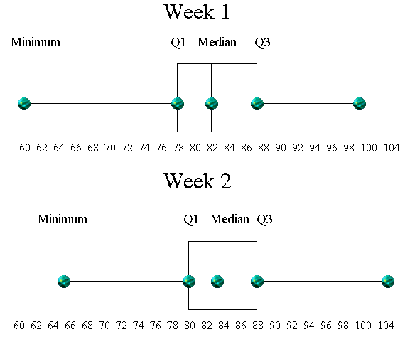
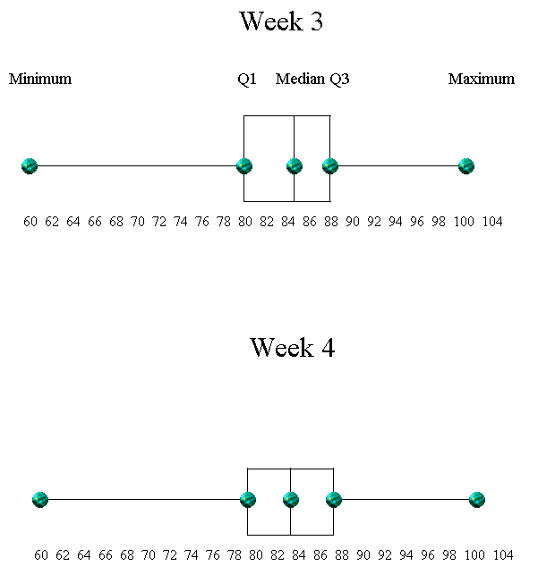
To get a representative analysis of each week, we created a box plot to characterize the maximum temperatures for each weekly period. The Median values were similar for each week, 82, 83, 84, 83 respectively, with the largest value occurring during the 3 rd week. The greatest minimum maximum temperature occurred during Week 2 and was 64. The remaining weeks had similar minimum maximum temperatures (approximately 60) over the 55-year period. While Week 3 had the greatest mean and median maximum temperatures, the maximum maximum temperature occurred during Week 2 (104).
While the ranges (Q3-Q1) were similar, a skew in the distribution was observed for all weeks except Week 4. For Weeks 1 and 2 the median value was closer to Q1, while for Week 3 the median was closer to Q3.
Summary
The following facts are a summary of the data analysis for the heat wave project:
- The third week of July in Madison is, on average, the warmest of the year.
- The maximum temperature peaks at two times during the month, the 16th through the 18th and the 24th through the 27th.
- The Median temperature values range from 82 degrees to 84 degrees.
- The Q3 points are always between 87 and 88 degrees
- The minimum maximum temperature is 60 degrees, while the maximum maximum is 104 degrees.

